Haicot – an altered Great War monument

In the forest high above the Col de Bagenelles is a beautiful mosaic created by German soldiers in the Great War. Its text identifies the creators as Landsturm Friedberg and it depicts a proud, growling crowned lion bearing a sword. It is the Hessian Lion – Btl Friedberg was a Hessian unit.

Haicot lion compressed

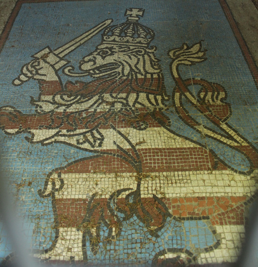
(The edge blur is because the precious mosaic is protected by a shelter.)

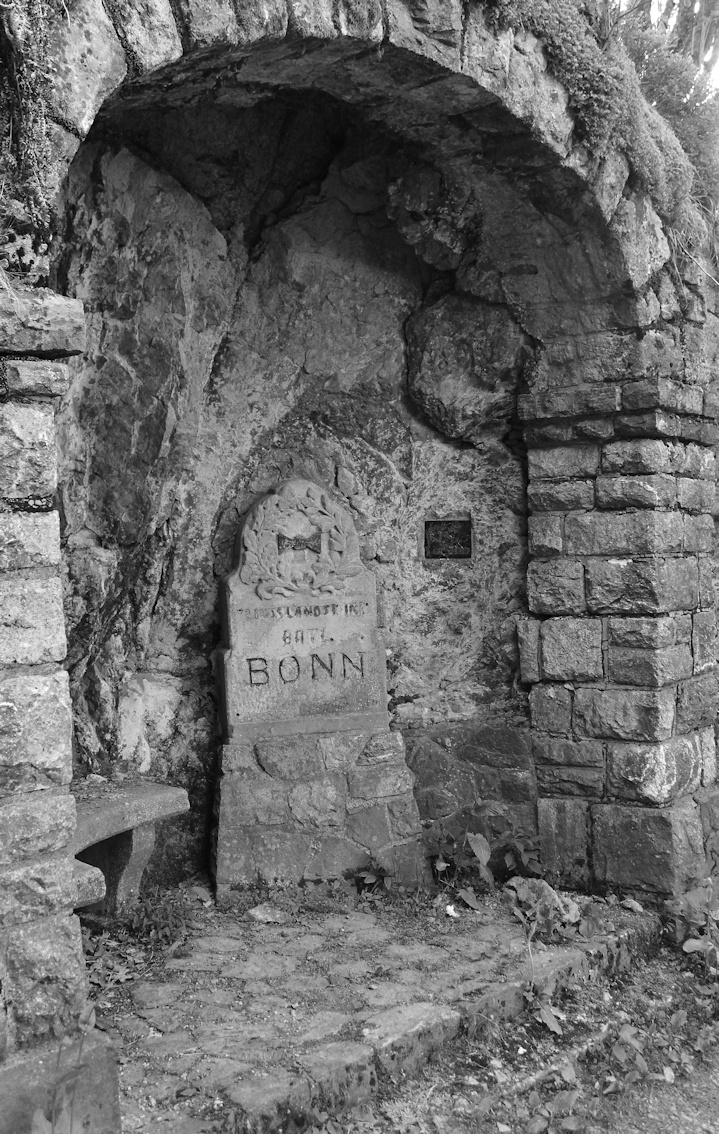
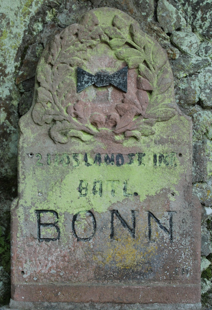
In the woods in front of the mosaic it’s easy to pick out vestiges of trenches. Walking on, eventually the path curves round the flank of the mountainside and unexpectedly you come to a small grotto which contains a monument inscribed to  2. Landsturm Infanterie Batallion 2 “Bonn” part of Landsturm VIII. Armee-Korps / Coblenz. In 1918 it became 2nd Btl, of Landsturm Infanterie Regiment 48. (Thank you to Rob Schaefer @GERArmyResearch for the assistance in deciphering this and for the information about Btl Friedberg.)

I photographed the monument in 2013 :

Haicot Bonn monument 1 compressed

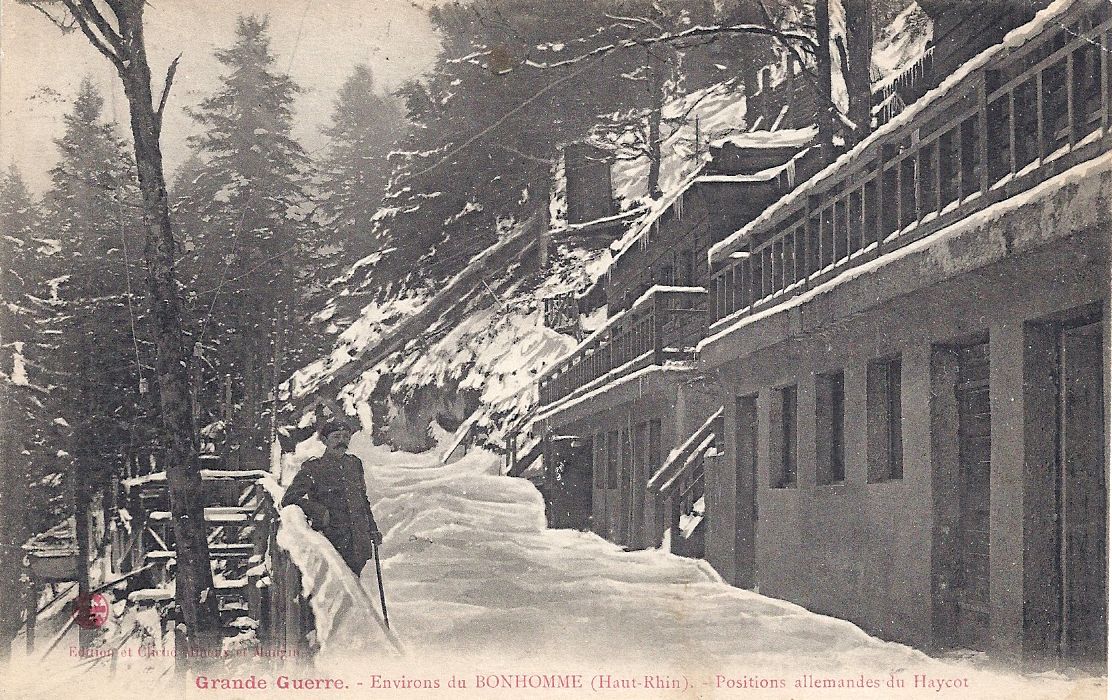
The 1920s postcard below shows the grotto; and adjacent to it is a projecting structure which I believe to be part of the German position at Haicot (alternatively spelt Haycot).

Haycot l'abri

This (below) is the monument in 2013…

Haicot Bonn monument 2 compressed (my photo)

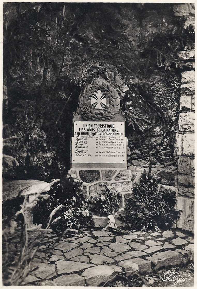
… and this (below) is a postcard photograph of it taken after the Second World War. The monument has been adapted to memorialise members of les Amis de la Nature who died in 1944. A close comparison of the ‘now’ photograph shows the holes where the Second World War memorial plaque was screwed in over the top of the original.

Haycot memorial

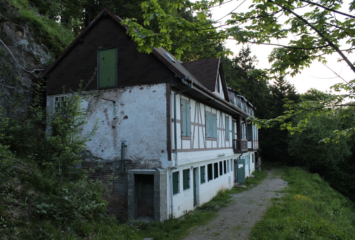
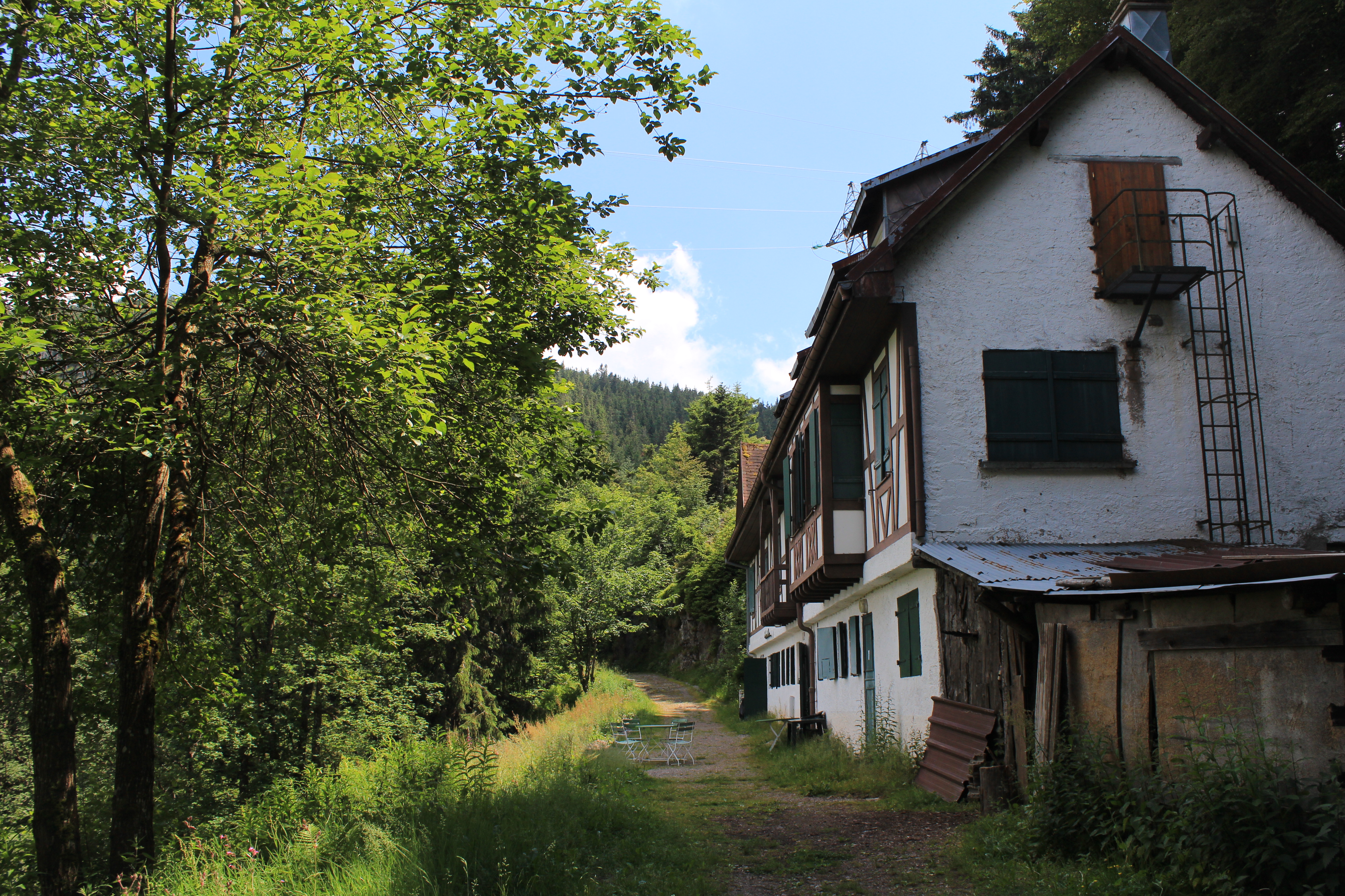
I have read elsewhere that l’Auberge du Haycot has been built on a German structure. While I do not know whether this is true or not, I believe that the author is mistaken.  Close to the Bonn monument is the Refuge de les Amis de la Nature Haycot, one of several refuges for walkers in the Vosges. (My photo, below, 2013) The owner of l’Auberge du Haycot told me that the refuge, not the Auberge, is the historic building.

Haicot refuge compressed

There was undoubtedly a German position at Haicot, shown in these two postcards from immediately after the First World War.

Haycot le Front des Vosges Abri Haycot

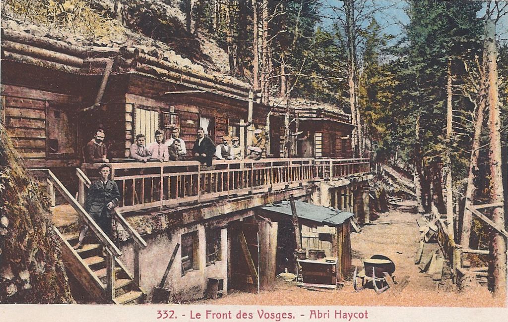
(Above. The  structure projecting over the slope ties in with that just visible in the early postcard showing the grotto: 331 Le Front des Vosges. 3rd picture from top, above.)

Haycot Positions allemandes du Haycot posted 1923

IMG_4507 (June 2014)

I am convinced that the ground floor of the current refuge is the same building as the ground floor of the premises shown in the postcards. The windows and doors match and there is early corrugated iron embedded into the wall. The landscape falls in the same way, steeply down the mountainside.

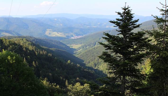
Provided that one isn’t attempting to walk to here from the Col de Bagenelles (a steep walk) and instead drives up and parks near l’Auberge du Haycot, this is an easy and rewarding walk in an important but less visited area of the early Front.

Haicot setting compressed

(My photographs and my postcards. Please don’t borrow them without asking.)

Rob Schaefer’s blog is http://gottmituns.net/ – very much worth visiting.

Jehanne d’Arc

On 30th May 1431 a young peasant girl from Domrémy in the Vosges was burned alive after an illegal trial for heresy in Rouen. During the period in which Alsace and Lorraine were annexed to the German Empire, she became a powerful symbol of resistance, of defiance, of eagerness for liberation.

Jeanne Ballon

The statue on the Ballon d’Alsace – on the French side of the hated border – of Jeanne d’Arc is still defiantly facing Germany, deliberately positioned to show that Alsace and Lorraine challenge their annexation. It was sculpted in 1909 by Mathurin and features in many postcards of the era; this one is typical and the text draws attention to the patriotic crowds at the inauguration.

Ballon d'Alsace statue de Jeanne d'arc

The inspirational figure of Jeanne is a recurrent theme in monuments and memorials after the oppression was lifted. Many Alsacien men were forced to fight for Germany, although it has to be remembered that anyone under the age of 43 when war was declared in 1914 had not known life as a French citizen and many were to all intents and purposes fully fledged Germans. Nevertheless, the theme of a young man being forced to fight for the oppressor is a powerful one and many patriotic images depict the despair of the young soldier and his family.

The mother depicted on the war memorial at Guebwiller pins a small rosette on her son’s chest under his jacket and tells him, “Remember you are French.” These rosettes were red, white and blue (the colours of the French flag). The memorial at Rosheim [below] shows a French poilu offering the open hand of friendship to a young man who has opened his jacket to reveal the patriotic rosette over his heart; his enforced pickelhaube has been discarded at his feet and Jeanne embraces the two in a gesture which emphasises the harmony and unity restored between France and her lost départements.

Rosheim Jeanne

The inspiration of Jeanne in times of oppression and war is reflected in her use in cemeteries. The village and community of Plaine, north of Saales, suffered dreadfully in the raging combats of 1914 as each side fought to gain control of the essential cols and the front moved rapidly. Jeanne was erected in this cemetery on 12th August 1923. The base of the statue says, “À eux l’immortalité, à nous le souvenir.”

Plaine cimetière militaire

In 2012. (There are British aviators and Muslim casualties among the graves.)

Plaine Jeanne

Menil-sur-Belvitte is a large 1917 nécropole nationale south of Baccarat and it is the resting place of a thousand men, many casualties from the Bataille de la Mortagne (1914) and the ghastly fighting at Col de la Chipote. Opposite the cemetery, peacefully surrounded by pastures with the characteristic Vosgienne cows, is a memorial privately erected in 1927 by l’Abbé Collé, the village curé. He also established a small commemorative museum which was destroyed by German troops in 1944.

Menil Jeanne

The essential figures on this memorial are in gold; one is Jeanne (“custos patriae”) at the pinnacle and the others (in what seems like slightly toned down gold) are the brave heroes of the 13th, 14th  15th  and 21st Corps d’Armée 1914.

Jeanne Menil Jeanne 2

It is a memorial of unexpected height and power; the loyal Chasseur figures, bravely ready for any challenger and in death cared for by a despairing figure of Mary, demand attention. Jeanne’s immense elevation, her raised cruciform sword and her striking gold armour communicate as a symbol of defiance and inner strength even today. Your eye is drawn upwards from the brave soldiers to their alleged inspiration as they fought to regain Alsace and Moselle for France.

Note. Published to mark the feast day of Ste Jeanne d’Arc, 30th May 2013.

More interesting material on Jehanne here: http://www.maidofheaven.com/ and http://mrssymbols.blogspot.co.uk/2012/12/arms-and-maiden.html

Crossing the frontier before the Great War – the Cols

 Rainbow over Reichackerkopf

(Rainbow over Reichackerkopf, 1915 battleground. The valley rises eventually to Col de la Schlucht, to right of photograph, off scene)

The landcape of the Vosges is mountainous and very beautiful; it forms deceptively rounded peaks rising to a series of summits called les Ballons. West of Thann, the Ballon d’Alsace is 1247 metres (4091 feet) and the Ballon d’Servance is 1216 metres. The Grand Ballon, west of Guebwiller, is 1424 metres (4672 feet). Le Hohneck, west of Munster, is 1363 metres (4472 feet).

It’s an exceptional area. The wild, silent forests with towering pines, still mysterious pools where dragonflies hover in summer, high open pastures of the Hautes Vosges dotted with the distinctive Vosgienne cows, waterfalls, peaty bogs and meadows of mountain flowers are a natural habitat for diverse wildlife. In May, after six months of safe confinement down in the lower farms, humans herd the cows up into the high mountain pastures where they run with their new freedom in a cacophony of hundreds of cow bells: transhumance is a cause for celebration and festivity. The mountain products are sought after and relished: cheese, hams, honey, kirsch. Alsace wine is very special. Biodiversity flourishes even in sites ravaged by war. People come to the Vosges to walk, ski, drive, cycle; to examine flora and fauna; to investigate rocks and minerals; to eat well or stay in peace; to buy produce to take home; to enjoy the hot brightness and the mountain air after the humidity of the Rhine plain in summer, or to have fun in the deep snows. It was equally a source of pleasure, exploration and challenge before the Great War.

Ballon d'Alsace La Borne et le Sommet (cars)

Access through the Vosges is historically through a series of cols. When Alsace and Moselle became the newly-named Reichsland Elsaß Lothringen, the cols ceased to be the passages from one department to another: they became the legal crossing from one state to another. Travellers and tourists still visited the Vosges and they crossed the frontier with a mixture of bewilderment, curiosity, anger, despair, sadness and astonishment, evidenced by the thousands of postcards on sale and their poignant hand-written messages.

Patriotic cards showing the return of Alsace and Lorraine to France were popular before and during the Great War, then sent by soldiers who perhaps didn’t wish to depict the awful scenes they witnessed, or perhaps written by senders who wished to encourage and motivate. Some of the minor cols were heavily fought over because of their strategic importance: Col de la Chipotte (south west of Raon l’Étape) is less famous than the well-known sites such as le Linge and le Vieil-Armand / Hartmannswillerkopf but the human suffering and loss on both sides there in August-September 1914 was appalling.

 Patriotique l'Arrivée des Diables Bleus

(Card posted 1915. The woman on the left wearing a black coiffe represents Alsace, the one on the right Lorraine.)

The map shows the main cols in the Vosges, approximately marked. I’ve also included the summits of the Ballon d’Alsace and Hohneck. North of the map area were the cols of Donon (west of Molsheim) and Hantz (west of Barr). I will feature each of the cols in forthcoming individual pieces. They are all worthy of special attention!

 Cols on map

I intend to write a lot more about the Vosges themselves later in the blog. For the meantime, there’s an interactive map here: http://www.parc-ballons-vosges.fr/la-carte-du-parc/

A tale of two posts: les poteaux sur les frontières

After the establishment of the new German state, it was essential for the German authorities to indicate the new boundaries as quickly as possible. At each of the crossing points through the Vosges mountains, they erected wooden posts painted in the German colours. But soon it was obvious that these were susceptible to the extreme weather variations and to vandalism.

By contrast, and probably understandably, the French authorities were rather slow in marking the hated frontier and eventually, in 1885, the German ambassador had to intervene and insist that the work was carried out, arguing that there were risks to France in not indicating the border. A survey was carried out to evaluate the problem and twelve crossing points were identified. Reluctantly, the French agreed to erect their own posts. The Ministry of the Interior made a grant available to fund ten posts at the most important crossings and they were ordered in July, 1886, from a foundry in St-Dié. The Ministry of Public Works funded two more, one at the Col de Ste-Marie between St-Dié and Sélestat and one at the Col du Bussang north of the Ballon d’Alsace. They were in place by the end of 1886. Painting them was considered too expensive.

 Col de Ste-Marie & borne before War written 1918

(Col de Ste-Marie. Borne centre, poteau to right)

Of course, they soon began to deteriorate. Newspapers began to complain about the shameful lack of maintenance of the national symbol, comparing them to the pristine condition of the German markers. Meanwhile the foundries of Kaiserslautern were busy making imposing plaques declaring to all travellers that they were entering the German Empire. From 1889, these were in place, dominating the less cared-for French markers, often mounted on striped posts in the Empire’s colours.

Col de la Schlucht frontiere franco-allemande 1911 2 people

(Col de la Schlucht, German and French customs officials)

Col de la Schlucht German customs, tram

 (Col de la Schlucht. Tram arrival, poteau to left.)

Many cards and pictures show the joyful destruction of these loathed posts in the early days of the Great War and many messages declare the writer’s pleasure in …

 Col de la Schlucht plus de frontiere

… ‘Plus de frontière!’

(Above: Col de la Schlucht, deserted customs building. The Hotel Français was destroyed during the Great War. More of that anon.)

A few words about bornes

Image

The Col du Bonhomme has been a route through the Vosges for centuries. It’s at the point where the main road from Nancy and St-Dié to Colmar crosses the Route des Crêtes, which was established in the Great War as a route along the ridge of the Vosges for the easier movement of French troops. It used to look like the card below posted in 1913 shows. As a border crossing between annexed Alsace and the rest of France, it was patrolled by customs officials and the frontier was marked with a metal plaque on a striped post: a poteau frontière.

Image

Behind the hotel at the left hand side of the picture, there are now woods, with footpaths tracking through. Before long, you come across stones set at intervals, like these two:

 Image

On closer examination, it’s clear that these are the original bornes frontières (frontier stones). The smaller, more rugged one was a rudimentary interim measure while the occupying forces of the German Empire had marked stones made. I think these date from the mid-1890s. The bornes were numbered and on this one it’s possible – just – to distinguish the number 207*.

 Image

Bornes marked the frontier at crossing points, at cols, across meadows and across high pastures (chaumes),  from the border with Luxembourg to the border with Switzerland. From Luxembourg to Donon they were the responsibility of the German authorities and France was responsible for the rest.  Originally the stones were not very visible and thus easily damaged by passing vehicles, or by disgruntled locals, so the bornes considered most at risk from traffic damage were painted white.

The original bornes were supposed to be just over a metre tall at the front with a face about 30cm across, with a base sunk into the ground to about 60 cm. They were lettered D (Deutschland) and F (France) and they carried their identification number. (It is often possible to distinguish the letters on the  bornes which remain.) Given the length of the new frontier, the necessity of marking it quickly and the difficulties imposed by the mountainous terrain, some were less well executed than others.

This borne is at the Col de Ste-Marie.

 Image

 Card posted before the Great War:

 Image

Tourists and travellers sent thousands of postcards showing the new controversial frontier posts. Their photos and messages evoke an era of longing and, as a visitor wrote to her cousin on a card I possess (translated):

 “So many regrets in these few words! Our Alsace. So close to us yet no longer of us!


A contemporary map

This is an extract from a larger map, unfortunately undated, showing  Elsaß Lothringen.

Elsass Lothringen map extract

 Towns and villages were given German names. Examples, working south:

Strassburg or Straßburg is Strasbourg

Schlettstadt is Sélestat

Markirch is Ste-Marie-aux-Mines

St Pilt is St-Hippolyte

Rappoltsweiler is Ribeauvillé

Münster is Munster

Gebweiler is Guebwiller

Sulz is Soultz

Sennheim is Cernay

Mulhausen is Mulhouse

(I have a directory of German placenames and am happy to give other translations.)

The blue line of the Vosges: starting with a little history

When you drive eastwards across France, you gradually become aware of a line of mountains in the distance and by the time you’ve passed Nancy, you’re in the beginning of foothills. The mountain summits seem to take on a blue cast and gradually, as you begin to ascend, you realise that you’ve entered a very beautiful mountain region: the Vosges.

 A little history. Napoleon declared war on Prussia in July, 1870. It was disastrous. The French army was poorly prepared and in the next three months suffered defeats which are marked on memorials in some French towns: names like Wissembourg, Froeschwiller, Strasbourg, Gravelotte, Metz and Sedan came to be remembered for French losses. In January, 1871, France surrendered. The new German Empire was proclaimed in Versailles in February. By the Treaty of Frankfurt, May 1871, France ceded Alsace (except Belfort) and most of Moselle to the German Empire.

 A new frontier was devised. In May,  the départements of Alsace and  Moselle became the newly-named Reichsland Elsaß Lothringen. The Treaty made provision for people to leave the areas and go to France: 125000 people did so. After that, those who remained lived under occupation, males being required to carry out military service in the German Army, civilians bound by laws enforced by German officials and the army.

 The natural frontier was the summit of the Vosges mountains. On the western side was France, minus Alsace, part of Lorraine and most of the Moselle department; on the other was Germany and the annexed regions. The watershed formed a natural boundary along most of the frontier as far as the Ballon d’Alsace except for the Donon region. The crest line became known wistfully as la ligne bleue des Vosges.

Blog Picture map Schlucht showing border

 (Frontier marked by me.)

The lives of the inhabitants of the region changed markedly. Access through the difficult Vosges mountains was historically through a series of cols, which became part of the new artificial frontier.  Customs officials of both countries patrolled the new border crossings between annexed Alsace and the rest of France. The German administration quickly erected poteaux frontières in the Empire’s colours, on striped posts displaying the German eagle in a circle. A long series of bornes frontières [boundary stones] was set in place and still can be spotted today. The stones are a reminder of one of the causes of the Great War.

France wanted the annexed regions back.

Patriotic Poilus Strasbourg in distance Hugo quote

There is a valid argument that these regions historically belonged to Germany. However, I don’t intend to discuss that; there are plenty of good sources of information on the Internet.

I intend to dip into the scenes of life in Alsace and the Vosges during the period before the Great War, using my own collection of postcards, maps and documents and my own photographs. I hope you enjoy them.

Patriotic O France!... bouclier de Paix

Debout les Morts!

Bringing the French experience of the First World War on the Western Front to English language speakers

WW1 Revisited

A Great War Journey with Paul Reed

Lordynges, Lystenyth

Children's stories lovingly adapted into Middle English verse by Hollie L. S. Morgan

midasinreverse: ian o'brien

Poetry, thoughts, rants by @OB1Ian

In That Rich Earth...

Great War History - reviews & articles

Expériences étrangères

Expériences étrangères

WW1 Centenary

Great War Centenary 2014-2018 website by Paul Reed

halfmuffled

Looking at the members of the Surrey Association of Church Bell Ringers who served in the First World War, and closely related matters

Blindfold and Alone

The trials of British Soldiers convicted in Capital Courts Martial during the Great War

%d bloggers like this: